

By Terrill-Smith (Contributor) – Email
The Trans Canada Trail comprises the longest network of recreational trails in the world. Stretching from the west coast of Vancouver Island to Canada’s east coast, one notable portion of the trail — the Rotary Trail — runs through Chilliwack, which allows you to enjoy various sections of the north dyke of the Vedder River. While the trail also offers up spectacular views of the surrounding mountains (including Cheam and Slesse), perhaps its most significant feature is its multi-use nature.
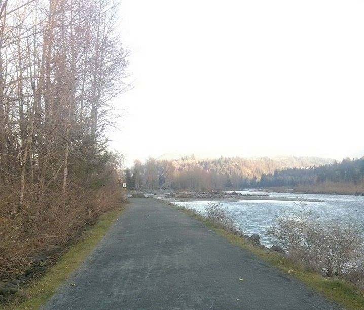
The Rotary Trail is a gravel trail located within the Vedder Greenway, which is the floodplain area of the Chilliwack and Vedder River extending from upstream of the Vedder Crossing Bridge to the Highway 1 crossing of the Vedder Canal. Since the trail runs along a floodplain, it is naturally flat, and therefore conducive to many different types of activities. Walkers, joggers, cyclists, dog walkers, and horseback riders can all be seen sharing the trail simultaneously, demonstrating that while the trail has a fundamentally easy degree of difficulty, you can increase the difficulty by engaging in more strenuous activities.
Although a consequence of the trail’s multiple uses and resulting popularity is congestion, there are helpful signs along the trail indicating right-of-way (cyclists yield to pedestrians and horseback riders, while pedestrians yield to horseback riders). And remember to always keep right! There are also other helpful signs as well. For example, markers exist for every kilometre of the trail, which extends approximately eight kilometres from its start at the Vedder Road parking lot to its junction with the Vedder North Dyke Trail west of the Great Blue Heron Reserve. The markers are particularly useful for those walkers and joggers wishing to keep track of their distance travelled, and if you’re exhausted from a taxing jog or run, benches and picnic tables along the trail offer a place for respite. There are also portable toilets, including wheelchair accessible ones, for when needed.
If you’re driving in from Abbotsford, it’s important to note that there are parking lots at Vedder Road, Peach Road, Lickman Road, Hopedale Road, and the Great Blue Heron Nature Reserve.
The most scenic, and therefore most popular, stretch of the trail runs from Vedder Road to Lickman Road, so keep this in mind. In other words, if you’re looking to go on a cathartic, solitary walk in nature, you’re best to park at Lickman Road and walk west toward the heron reserve.
Lastly, because much of the trail follows the east bank of the Vedder River, easy access to the river for fishers is provided, further proving the trail’s truly multi-use nature. However, although you won’t see fishers at this time of year, you are still free to walk, jog, or bike the trail. After all, just because it’s getting cold, that doesn’t mean you have to stop being active!
